Bircham Springs Petroglyphs 

 It was early Saturday morning and our little four car caravan was getting a thorough going-over from the guards at the main gate to the China Lake Naval Air Weapons Station. Hoods were opened, mirrors were used to check under the vehicles, bags and boxes were examined, and all cameras had to be locked away until we arrived at our destination. We were, after all, entering a very top secret area. I'm sure the ancient Shoshone and Paiute Indians would chuckle over what has become of their territory! Our destination was Bircham Springs. The high plateau on the east side of the Argus Range where the springs are located was once more accustomed to the chipping of obsidian than the thud of ordinance; to the whistle of an arrow or atlatl spear in flight than the roar of a combat jet. Our guide today was Joel Briggs, author of the marvelous Desert Drifter web site (no longer available) and prototypical Indiana Jones style archaeologist. The rest of our eight person group was composed of Danny, Jose, Henry, and Brian, all "friends/research assistants" of Joel; Niki and I; and the soft spoken but highly qualified peak bagger and chaperone for the Maturango Museum, Loren.
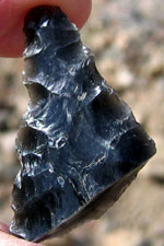 Our route to the site took us around the east edge of China Lake, once the Pleistocene home of sloths and mammoths, and later of Paleo-Indians who occupied the marshy lake margins. Soon we turned due east and began to climb up Mountain Springs Canyon on a road originally built by Remi Nadeau as a freight road in the 1870's. This same road later became the route of the Brown to Darwin stage. Old mines and tailings piles flashed by as we continued our climb. Soon we began to see a few scattered Joshua Trees, and then they multiplied into a veritable forest. In fact this high plateau is home to one of the world's largest Joshua Tree forests! To the east loomed the Panamints with Telescope Peak still wearing a mantle of snow. Soon the road ended and our destination was reached. We would use the Bircham Springs picnic area, built in 1972 by the Seabees, as our base. The air was brisk as we unloaded gear and set up camp prior to hiking into the surrounding hills. What we would be exploring would be an area that was used by the early hunter-gatherers in the late spring or early summer. It was then that they would leave their winter camps at the lower elevations and move to higher country to harvest early ripening seeds and greens. Later in the summer and early autumn they would move even higher to harvest the pinion nuts which would be used as a winter staple in their diets. Hunters also combed the area for game such as bighorn sheep, deer, rabbits and rodents.
Take a couple bottles of water, throw something warm in your backpack, and join us as we hike up the wash to Bircham Springs proper. Along the way we'll see numerous obsidian flakes, a rock shelter, an old stone miner's cabin, the spring site, and then along the high ridge to the east we might even find a few of those well-earned petroglyphs! When you've got your gear together just click on the photo link below.