East of Opal Mountain 

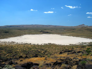 The topographic maps show a small dry lake to the east of Opal Mountain in the Mojave Desert of California. We were curious. What was it like there? Since it's near Inscription Canyon and its petroglylphs, would this area also show evidence of Indian occupation? There was only one way to find out! We set out in the Lizardmobile for a quick trip on a warm day in mid-June.
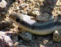
If you'd like to join us on a cyber version of this scouting trip, we'd love to have you along! A mouse click on the photo link below will show you some of the highlights of the day. Your first stop will be a small canyon that has several nice petroglyphs and lots of chuckwallas. Chuckwallas have excellent eyesight, and these were no exception. The only photos we got of them were of the telephoto variety. Next, you'll travel to a jewel of a dry lake nestled between a lava ridge and several lower hills. On the jumbled lava ridge on the east side of the lake we'll hike up to a small rock shelter decorated with petroglyphs and cupule marks. After the steep hike, If you have any energy left, you can join us in the hunt for two Geocaches on the perimeter of the lake. Finally, a short drive to the west will take us to a cluster of rock circles that again seem to hint at prehistoric Indian occupation in this area. As a bonus, exploring around these circles is likely to turn up some nice common opal as float in the streambeds. Let's get started!